Out the Other Side

June 30, 2018

We were ready on time. There is a rhythm to breaking camp in the morning. Even after just a few days, it becomes comforting. Also, I noticed the lightness from having consumed three days worth of food.

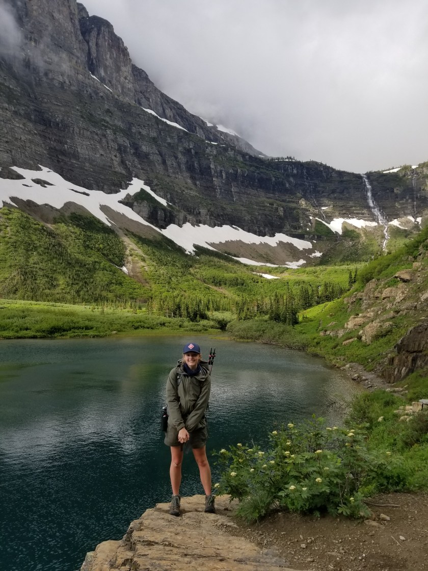
Today we would climb 900 feet through Brown Pass and then descend over 2,000 feet, ending with a six mile hike alongside Bowman Lake. I was leery of another icy pass, but it turned out to be snow free. Before dropping over, we took one last look east into Glacier.

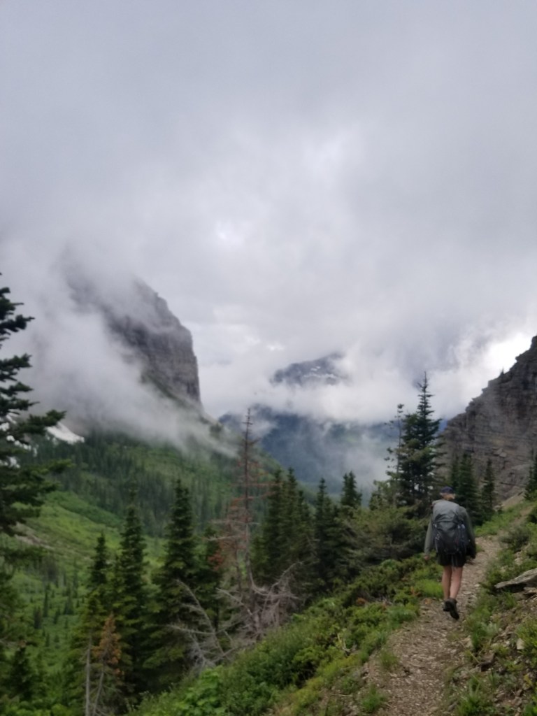
The steep descent was made more challenging by fallen trees across the trail, a reminder of how severe the weather can get over the winter. Ingrid was a natural for choosing from a) under b) over or c) around.

Eventually, we heard chainsaws. Then, we saw the crew. They were working on a huge 3 tree collapse across the trail. I sent Ing down and around to get the chainsaw worker’s attention. Never, ever surprise someone operating a chainsaw.

I took the high route above where a massive tree’s roots had been pulled from the ground. It was about 8 feet of loose rock sharply down to the trail. I took two steps, then both my feet flew out and I landed flat on my backpack on the trail right in front of the trail crew supervisor. He complemented me on my grand entrance.

It drizzled off and on as the gray clouds clung to the mountainsides. We were making good time. In reality, I could not keep up with Ingrid. I think she felt sorry for me and every 30 minutes would stop and wait for me, ostensibly to check the map on my phone.

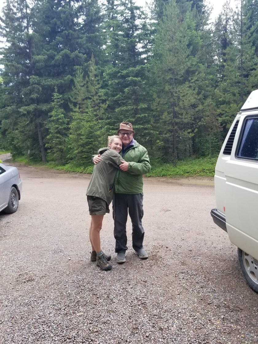
We had made plans to meet my Dad at the campground at the foot of Bowman Lake. That, combined with the prospect of cooked food, a shower, and a bed was exceedingly motivational. Almost exactly on time, we found him and he was happy to see his granddaughter.

After a snack, we headed first to Polebridge Mercantile for some baked goods and then on to West Glacier for dinner and a motel near the Amtrak stop.

For me, this his has been an incredible trip. Usually, I schlump along and take photos to communicate to others what I saw. However, on this trip I was able to share the experience with my daughter. I hope she enjoyed it enough that one day she will take her son or daughter to watch waterfalls and mountain lakes. Plus, being able to end the trip meeting up with my Dad, who tried to instill an appreciation of nature in me, was an extra blessing.

Stoney Indian Pass

June 28, 2018

(Apologies but my blog vendor, WordPress, has deployed a brilliant business strategy of preventing customers from loading photos remotely. I’ll try to keep Instagram updated with photos. )

The wind at Coseley Lake died down during the night, offering a gorgeous mountain-reflected-in-the-lake view.

We broke camp and started what we knew was going to be a tough day: about 2,200 feet over Stoney Indian Pass.

At first, the trail climbed gently with a lush understory. The weather turned a little overcast, but that actually makes for good hiking. We ran in to a trail crew that had been doing trail maintenance. This was welcome news. Over winter, trees get blown down or avalanches and landslides knock trees across the trail. They are a pain to get around. Thus, we were fortunate to have them clear our way.

We started gaining elevation and encountering waterfalls. Above one we could look down and across the stream and see a huge reddish brown grizzly grazing.

At a higher level, we climbed into a bowl shaped area that had twin waterfalls feeding a crystalline pond.

Climbing still further, the temperature dropped and blotches of snow appeared. We climbed past still another waterfall and just above it we had to cross the ice fed stream. I hike in mesh trail runners and keep them on for stream crossings. Plus, I use a hiking pole to cross facing upstream so I am basically moving a triangle across. I sure as hell don’t link arms. Ingrid wanted to keep her boots and shoes dry and cross barefoot. Reluctantly, I let her do that. I remembeted that Q-tip did that on the CDT. Knowing that in such cold water your feet hurt after 7 seconds and start numbing after 10, I crossed right behind her, downstream. There were definitely some nervous Dad moments as I watched her struggle the last few feet as her feet (and mine) grew numb and had trouble finding the next step with the waterfall only about 20 feet downstream.

We were now entering areas where the snow fields covered almost one third of the trail. It started drizzling and we donned rain gear. Finally, after a rigorous set of switchbacks and a good sized snow field, we reached Stoney Indian Pass.

The views were amazing. As the clouds thickened, they began enveloping the uppermost peaks. The rest of what was visible was gray stone with snow accents. Several hundred feet down from us was Stoney Indian Lake. Clear parts were blue, but a portion was covered with ice and obvious avalanche debris. This was going to be a steep descent on a north-facing wall. Rhonda and David had given us some tobacco and explained a humble ceremony which Ingrid and I performed.

As we started going down, I insisted Ingrid take my ice axe. I broke out my hiking poles. At the top, almost the entire trail was under a steep snow bank. We could barely discern the trail, cobbling together melted snippets and the vague footprints of a couple people who went before us a day or so earlier.

More unnerving than the waterfall, I was seriously concerned about Ingrid slipping and sliding down hill into a tree or rock. So, we eventually came up with a plan to bushwhack our way through the areas barren of snow and intercept the trail further down. After a nerve wracking hour, we eventually found a flatter portion of the trail. About 50 feet before reaching the lake, we did our best shoe skiing down the last slope which was fun and a release from the tension.

After the lake, we crashed down several hundred feet and a good six miles to Kootenai campsite. We were both tired. We opted for an early dinner. Even though campfires were permitted at this site, we both chose to just go to bed. For those of you who know I am a bit of an insomniac, seeing me go to bed by 8:30 would shock you.

Beside a lake with a gentle breeze and a thick, lush forest behind, it was no surprise I fell into a deep sleep right away. Until the sticks started breaking somewhere in the woods.

Why Brave the CDT?

I have committed to hiking the Continental Divide Trail starting in June, 2016. Here is a little bit more information about the trail and why I selected it.

What does CDT stand for?

The most relevant meaning of CDT is the Continental Divide Trail.  It connects the northern and southern borders of the United States while striving to stay as high as possible along the Continental Divide of the U.S.  Officially, it is the Continental Divide National Scenic Trail as defined by the National Park Service (NPS).   The NPS lists 10 National Scenic Trails.  Most people familiar with backpacking in the United states think of the three main north-south routes: the Appalachian, Pacific Crest, and Continental Divide trails. Completion of  the three main trails earns the title of “Triple Crown” although as American Pharoah might clarify, it is a backpacking triple crown.

The route crosses all forms of land ownership.  While mostly on federal government lands, the trail also crosses state and private land.  It combines formally marked trails with roads, paths, and, at times, sketchy bushwhacks.  Indeed, there are actually a variety of routes one can take that fulfill the spirit of the trail compared to the formal “official” 3,100 route.  My brief survey of southbound hikers who kept journals on either Trail Journals or Postholer between 2006 and 2014  found that there were 38 succesful completions.  Of these the  average trail distance was 2,491 miles and they completed with an average time of 141 days.  (Aside:  I noticed an inverse correlation between the amount of pre-hike journal posting and the likelihood of success.  Thus, I will try to only write a few pre-hike blog entries to avoid jinxing my trip.)

Who manages the CDT?

There is an umbrella non-profit organization that attempts to coordinate all matters concerning the CDT. Although the NPS has overall stewardship of the National Scenic Trails, it relies on non-profit groups to actually coordinate the day-to-day management of trails.  In the case of the CDT,  It is the Continental Divide Trail Coalition (CDTC).  I have donated money over the last few years and hope that others will also contribute as the CDTC leads lobbying, trail maintenance, and community relations efforts.  I did receive a t-shirt from them with their motto:  Brave the CDT.

Besides Central Daylight Time, CDT is also the acronym for Clostridium Difficile Toxin.  I had that little bacterial gut bomb  after my appendectomy several years ago.  You can look up the symptoms and treatments yourself, otherwise you can take my word that having CDT makes you feel crappy.  I recovered and now hope to complete this hike and Brave the CDT a second time.