Not the Finest Day

July 2, 2018. Blue Sky Creek junction with Forest Road 114

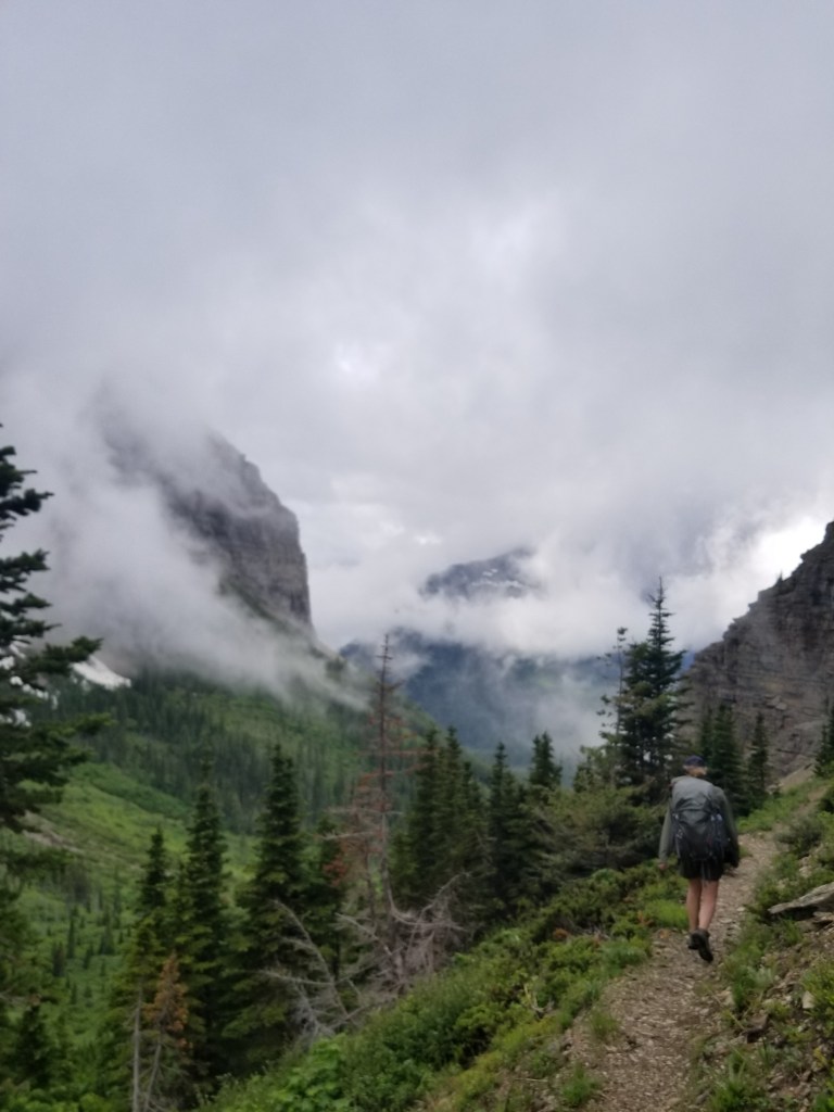
I woke up feeling pretty good. I packed quickly and noted the weather was slightly more sunny than cloudy. Today would be up along the ridgetops. These kind of hiking days are love / hate. If the weather is clear, they are lovely with views to the horizon. Stormy and you hate almost every minute.

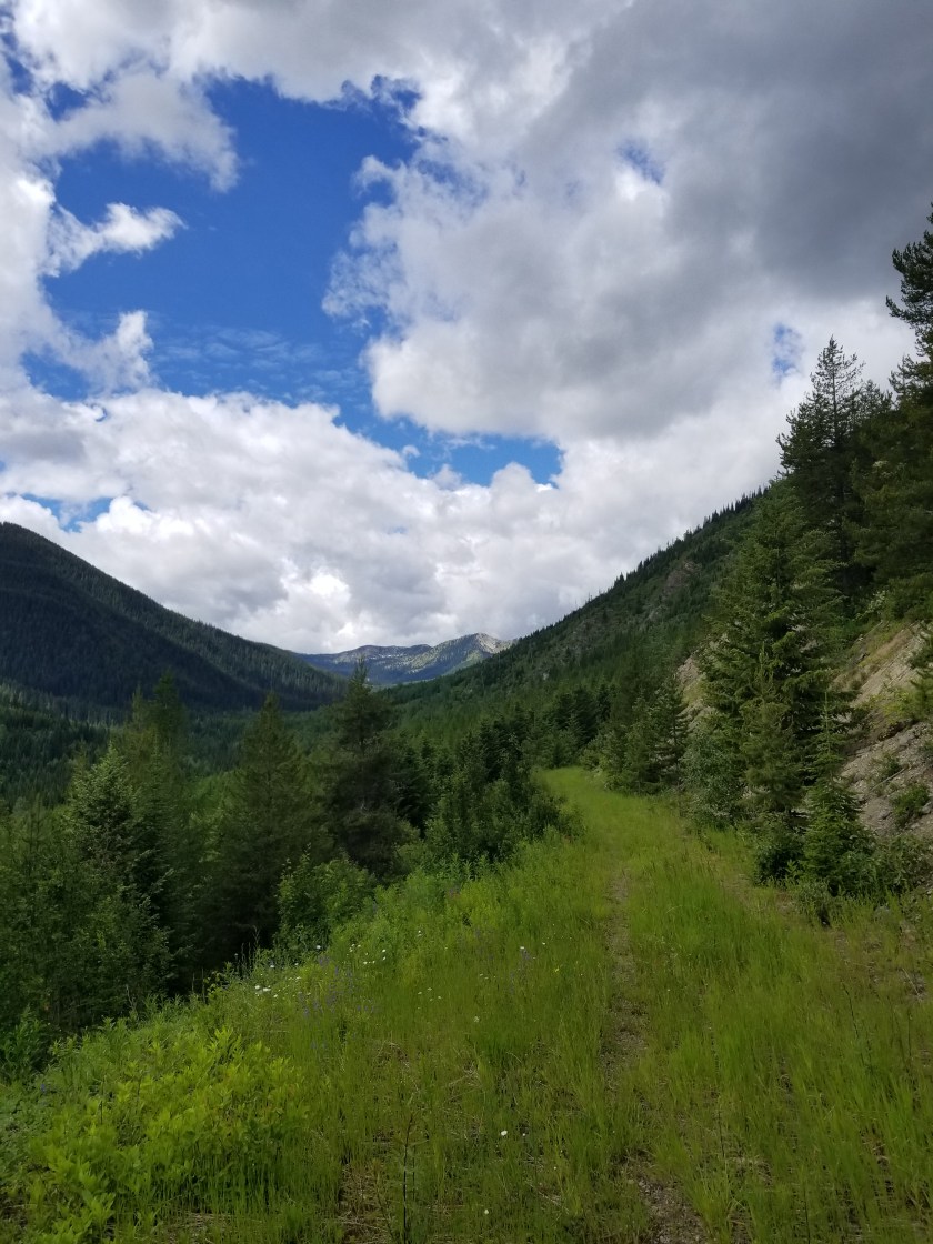
The snow mounds were limited at first. Limited to trees and northern areas. Indeed, the views were pretty good. Once I came to my first ridge, I could see the trail going up the next ridge in the distance.

I could see the trail climbing the mountain ahead.

On a whim, I turned on my phone and got reception. It is very random how connectivity appears on one mountain and not another. I did the only reasonable thing I could and that was check social media.

I started cruising along the ridges. From the footprints, it looked like two people were about three or four days ahead. That was a relief from a route-finding perspective. The snow became almost continuous on the ridge.

After about 30 minutes, the footprints were overlapped by a more recent traveler: a bear. It was cool to see how the bear used the trail, even following on switchbacks. I presumed it was not stalking the others and it did not seem fresh, so I was not worried.

Another traveler joins the trail.
Although the snow melt made it bigger, here is a comparison to my size 13 shoes.

It started drizzling. The views disappeared. I stopped for a snack and had a hail storm roll over. The hail turned to graupel then snow. I entered an area that had burned the prior year. It felt eerie. The ground was charrred and skeletons stood, half burned, large charcoal logs. The white snow contrasting with the black reminder of what must’ve been a hellacious fire

The weather gets bad over the burned out forest.
It was eerie, almost like walking through a graveyard.

I stopped just short of the top of Mt. Locke, 7,200′. The wind really picked up, driving the snow almost horizontally. I made a sarcastic video about the elements and wondering why more people don’t go backpacking. Within 20 seconds of finishing, a massive lightning strike hit nearby. “Holy Mary Mother of Jesus” ( I’m paraphrasing). I knew this was very bad and I had to get down.

I sprinted the 50 feet to the summit, following a clear trail. However, the trail stopped at a sheer dropoff. There were the obvious remains of a former lookout tower, two sheer sides, and the slope I came up. I was stumped and a little panicky. “Where the f*** is the trail?” Please understand that at that moment I am the tallest living thing around and I am carrying two carbon fiber hiking poles in a backpack with small aluminum stays.

I whipped out my map, but it didn’t help. I ran down the trail, resolving to take my chances in the charred landscape I had just come through. However, out of the corner of my left eye, I caught a small flat spot on the blackened ground. I looked and sure enough it was the trail leading away from the top.

My mind kept up the refrain “This isn’t good. I’ve got to get lower.” For my age, I did a pretty good job running down the foot-wide path. However, the trail was only about 30 feet below the descending ridgeline. In short, while I was losing elevation, I was still relatively exposed to the high point. Soon, I saw a sequence of trees along side the trail. I set my sights on the shortest one. First, I stashed my hiking poles. Next, I dumped my backpack. Then, at last, I assumed the position near the short tree. Supposedly, you should squat down as this creates the least amount of body for a lightning bolt to transit. (Not to be cynical, but I did try to imagine how much chipper I might be if lightning only traversed a three foot squatted me versus a six foot standing me.)

Unfortunately, another bolt struck. It was close. Deafening. It made the air smell weird. You know that thing where you are supposed to count “One Mississippi ” to gauge how far away the bolt struck? Well, this was at “O”.

Considering my age, the fact I was squatting, and the proximity of the strike, I was proud that the only thing to come out of me involuntarily were some swear words.

Hoping that the electrical component would move on, I decided to wait 20 minutes. No more lightening occurred and the storm’s fury eased noticeably. I grabbed my poles, backpack, and pep-stepped down the trail, eventually reaching a junction that would pull me off the ridgeline. Ironically, I was now on the Bluesky Trail.

Leaving the stormy ridgeline to join the Bluesky Trail. Note the Pacific Northwest Trail marker below the trail sign melted in the heat of last year’s fire.

The next two hours were spent descending a steep trail in a slow persistent drizzle. I stopped to put on my rain pants and noticed how scarred and blackened my legs were from climbing over charcoaled trees in the burn area. I also realized I had lost my glasses in my panicked run.

After the steep trail and clambering over blow downs, I came to an abandoned road that was now the trail. Oddly, about 5 miles from the parking lot at the start of this trail, I came across an abandoned wheelbarrow.

Pushing a wheelbarrow five miles uphill was a feat of strength and futility for some soul.

Those last miles were wet and slow, but around 6:00 I reached the parking lot, came back up the trail a bit, and set up a soggy campsite in a meadow. Almost 11 hours to cover a lousy 19 miles, but I was glad to be alive.

Going Solo

July 1, 2018. West Glacier, MT.

We were to meet for breakfast. Ing would get on Amtrak back to the twin cities and my Dad would drop me off at the trail. Amtrak notified us of a massive delay (four hours). So we ate breakfast, then Dad & Ingrid took me to the trail.

We said goodbye on a Forest Service road. I was glad Grandpa and Ing got some bonus time together, but a little sad to be on my own.

Again, the clouds hung low as I walked for a few hours on a gravel road. The mosquitoes were fast. Usually I can out-walk them, but these guys ingeniously drafted me and got the back of my legs pretty good. Eventually, it started drizzling so the little buggers disappeared and I popped open my umbrella.

Amazingly, I saw another backpacker. I caught up to her. Originally from Israel, she has lived several places and hiked some long trails, like the Colorado Trail, which overlaps part of the CDT.

The road eventually turned into an abandoned forest service road. I saw my first official PNT trail marker. Alders and huckleberries grew in from the sides. It was a great way to use an old road. The Forest Service cant afford to maintain all their roads. I read somewhere they were the equivalent of the largest construction in the world.

While this trail was good for me, it was also a highway for bears. Indeed, on one section it seemed like a rest area. Needless to say, there was a lot of “Hey bears” from me along the narrow parts.

It switched to a real trail as I got higher. I stopped at the transition point. Two guys and a pack mule came by, said Hi and went on another trail. A real good cowboy chat that was.

Alders pushed in from the sides as the abandoned road turned to trail.

I descended the narrow trail across and down a steep slope. At the road at the bottom, I still felt strong so I went past the Red Meadow camp and pushed on.

Looking across the valley before Red Meadow
Looking down the valley before Red Meadow Camp

I missed my last creek water supply and settled for a snow melt pond just before I went on a trail again. I immediately encountered snow patches on the trail. Snow patches are a big hassle. You step up on them and, depending on the temperature and consistency, walk across, slide, or sink in to a deep hole. In short, it is slow.

Knowing the trail would soon climb a ridgeline and stay there, I found a flat, snowfree place to camp. I built a little fire to take the damp off the 20 mile day and went to sleep early.

Out the Other Side

June 30, 2018

We were ready on time. There is a rhythm to breaking camp in the morning. Even after just a few days, it becomes comforting. Also, I noticed the lightness from having consumed three days worth of food.

Today we would climb 900 feet through Brown Pass and then descend over 2,000 feet, ending with a six mile hike alongside Bowman Lake. I was leery of another icy pass, but it turned out to be snow free. Before dropping over, we took one last look east into Glacier.

The steep descent was made more challenging by fallen trees across the trail, a reminder of how severe the weather can get over the winter. Ingrid was a natural for choosing from a) under b) over or c) around.

Eventually, we heard chainsaws. Then, we saw the crew. They were working on a huge 3 tree collapse across the trail. I sent Ing down and around to get the chainsaw worker’s attention. Never, ever surprise someone operating a chainsaw.

I took the high route above where a massive tree’s roots had been pulled from the ground. It was about 8 feet of loose rock sharply down to the trail. I took two steps, then both my feet flew out and I landed flat on my backpack on the trail right in front of the trail crew supervisor. He complemented me on my grand entrance.

It drizzled off and on as the gray clouds clung to the mountainsides. We were making good time. In reality, I could not keep up with Ingrid. I think she felt sorry for me and every 30 minutes would stop and wait for me, ostensibly to check the map on my phone.

We had made plans to meet my Dad at the campground at the foot of Bowman Lake. That, combined with the prospect of cooked food, a shower, and a bed was exceedingly motivational. Almost exactly on time, we found him and he was happy to see his granddaughter.

After a snack, we headed first to Polebridge Mercantile for some baked goods and then on to West Glacier for dinner and a motel near the Amtrak stop.

For me, this his has been an incredible trip. Usually, I schlump along and take photos to communicate to others what I saw. However, on this trip I was able to share the experience with my daughter. I hope she enjoyed it enough that one day she will take her son or daughter to watch waterfalls and mountain lakes. Plus, being able to end the trip meeting up with my Dad, who tried to instill an appreciation of nature in me, was an extra blessing.

Stoney Indian Pass

June 28, 2018

(Apologies but my blog vendor, WordPress, has deployed a brilliant business strategy of preventing customers from loading photos remotely. I’ll try to keep Instagram updated with photos. )

The wind at Coseley Lake died down during the night, offering a gorgeous mountain-reflected-in-the-lake view.

We broke camp and started what we knew was going to be a tough day: about 2,200 feet over Stoney Indian Pass.

At first, the trail climbed gently with a lush understory. The weather turned a little overcast, but that actually makes for good hiking. We ran in to a trail crew that had been doing trail maintenance. This was welcome news. Over winter, trees get blown down or avalanches and landslides knock trees across the trail. They are a pain to get around. Thus, we were fortunate to have them clear our way.

We started gaining elevation and encountering waterfalls. Above one we could look down and across the stream and see a huge reddish brown grizzly grazing.

At a higher level, we climbed into a bowl shaped area that had twin waterfalls feeding a crystalline pond.

Climbing still further, the temperature dropped and blotches of snow appeared. We climbed past still another waterfall and just above it we had to cross the ice fed stream. I hike in mesh trail runners and keep them on for stream crossings. Plus, I use a hiking pole to cross facing upstream so I am basically moving a triangle across. I sure as hell don’t link arms. Ingrid wanted to keep her boots and shoes dry and cross barefoot. Reluctantly, I let her do that. I remembeted that Q-tip did that on the CDT. Knowing that in such cold water your feet hurt after 7 seconds and start numbing after 10, I crossed right behind her, downstream. There were definitely some nervous Dad moments as I watched her struggle the last few feet as her feet (and mine) grew numb and had trouble finding the next step with the waterfall only about 20 feet downstream.

We were now entering areas where the snow fields covered almost one third of the trail. It started drizzling and we donned rain gear. Finally, after a rigorous set of switchbacks and a good sized snow field, we reached Stoney Indian Pass.

The views were amazing. As the clouds thickened, they began enveloping the uppermost peaks. The rest of what was visible was gray stone with snow accents. Several hundred feet down from us was Stoney Indian Lake. Clear parts were blue, but a portion was covered with ice and obvious avalanche debris. This was going to be a steep descent on a north-facing wall. Rhonda and David had given us some tobacco and explained a humble ceremony which Ingrid and I performed.

As we started going down, I insisted Ingrid take my ice axe. I broke out my hiking poles. At the top, almost the entire trail was under a steep snow bank. We could barely discern the trail, cobbling together melted snippets and the vague footprints of a couple people who went before us a day or so earlier.

More unnerving than the waterfall, I was seriously concerned about Ingrid slipping and sliding down hill into a tree or rock. So, we eventually came up with a plan to bushwhack our way through the areas barren of snow and intercept the trail further down. After a nerve wracking hour, we eventually found a flatter portion of the trail. About 50 feet before reaching the lake, we did our best shoe skiing down the last slope which was fun and a release from the tension.

After the lake, we crashed down several hundred feet and a good six miles to Kootenai campsite. We were both tired. We opted for an early dinner. Even though campfires were permitted at this site, we both chose to just go to bed. For those of you who know I am a bit of an insomniac, seeing me go to bed by 8:30 would shock you.

Beside a lake with a gentle breeze and a thick, lush forest behind, it was no surprise I fell into a deep sleep right away. Until the sticks started breaking somewhere in the woods.

Day One

June 27, 2018

{NOTE My blog vendor, WordPress, is not allowing me to load photos remotely. I will try Instagram as a way to provide visual interest to the dry, crusty written word in my blog. Will add photos here later. Sorry.}

Yesterday, we made it to Many Glacier ranger station. We hoped to get a permit that matched the online reservation we made months ago. The challenge was that we requested a route over two passes and this was a heavy snow year. The ranger was hesitant to give us our route. However, we finally won her over with our microspikes, ice axes, and experience, plus a full-on charm offensive. I’m sure it was the microspikes.

We had to watch the bear video that also covers other hazards. The Park Service recommends that people ford rivers by linking arms and walking perpendicular to the current. Admittedly I am an amateur, but this seems absolutely daft. First, if the current is strong enough to knock one over, wouldn’t the rest fall like dominoes? Second, if my arms were linked to yours and I fell in, no matter how much I loved you, my fingernails would be two inches deep in your flesh, sealing your fate to mine.

Anyway, they gave us a permit for a route which they said was “not recommended.” I was very tempted to ask whether the ever recommended routes they did not permit.

We were able to check in to our motel early, drop our packs, and take a 10 mile hike. We took a popular out-and-back trip to Iceberg Lake. All shapes and ages and sizes were on the trail, almost all happy. Except for the parents of young kids who were stomping down the trail grumpy with grumpy kids.

As billed, Iceberg Lake had an iceberg. Also, there was that guy. You know, the one who understands that the park rules and several signs saying No Dogs applies to everyone else, not him.

The next day we were picked up by the shuttle taxi. It was very interesting to meet David and Rhonda. They live on the Blackfeet Reservation. They started the shuttle service to transport folks around the Glacier area. In addition to educating us about their culture, challenges on the Reservation, and their business. I was most impressed with how they have adopted four children in their community from parents unable to properly care due to drug or alcohol problems. I felt small next to them. They know full well that each of these kids are prone to the same problems as their birth parents, but Rhonda and David opened their hearts and home to give hope.

Around 11:00 we reached the Canadian border at Chief Mountain. We took the obligatory border photo and then started hiking.

The meadows were full of flowers and the forest was a lush green. We spent the first hour descending to the Belly River. Once there, we encountered several hikers and enjoyed the snow capped peaks. Just before we broke off the main trail we ran into the ranger who issued us our permit. She was hiking off-duty and was helping an on-duty ranger with an injured hiker. She checked our permit. Thorough.

We climbed up out of the valley and reached our destination after eight miles. It was Coseley Lake. As the park name suggests, most lakes here are long and narrow since they fill glacier carved valleys. About 150 feet across from our campsite rose a massive stone mountain. Behind behind us, another. While beautiful, the effect was a bit of a wind tunnel.

To manage bear vs backpacker issues, you must camp in designated campsites and each site has a separate food preparation and storage area. During dinner we met a young couple from Missouri on their second backpacking trip and a local, experienced mother-daughter team. It was great dinner conversation but we turned in early.

All in all, a great first day. Ingrid was a natural at finding the right route. The weather was perfect. A good start.